Cycling
There are currently several walking and cycling schemes proposed by B&NES which could improve access to safe cycling in New Sydney Place and around Sydney Gardens. This page summarises some of the main projects which will affect the area.
Beckford Road
According to the B&NES council, the Beckford Road scheme will provide a safe and convenient cycle facility, and improved pedestrian routes, as part of a first phase of putting in place wider cycling infrastructure linking the city centre to the canal towpath cycle route, the University of Bath and Claverton Down.
The project aims to:
- Encourage and enable more journeys by bike and on foot
- Improve the confidence of people to cycle and walk
- Give greater priority to cyclists and pedestrians on the road
- Improve the health and wellbeing of residents
- Support the council's wider work to address the Climate Emergency
The following changes are planned as part of the scheme:
- Creating a cycle lane which is separated from other road traffic, including buses
- Moving on-street parking to nearby areas
- Improving junctions, to make them safer for pedestrians to cross
- Redesigning a bus stop
In December, B&NES held a consultation on the Beckford Road scheme. This consultation closed on 4 January 2022. Local residents, businesses and the general public were invited to comment on the proposal (see the B&NES project timeline).
The map below shows existing cycle routes (purple), routes proposed as part of the current scheme (blue), and future routes that the council hopes to build (orange). The current proposal includes a cycle path on Beckford road, with a possible future route being indicated on Sydney Road and along New Sydney Place.
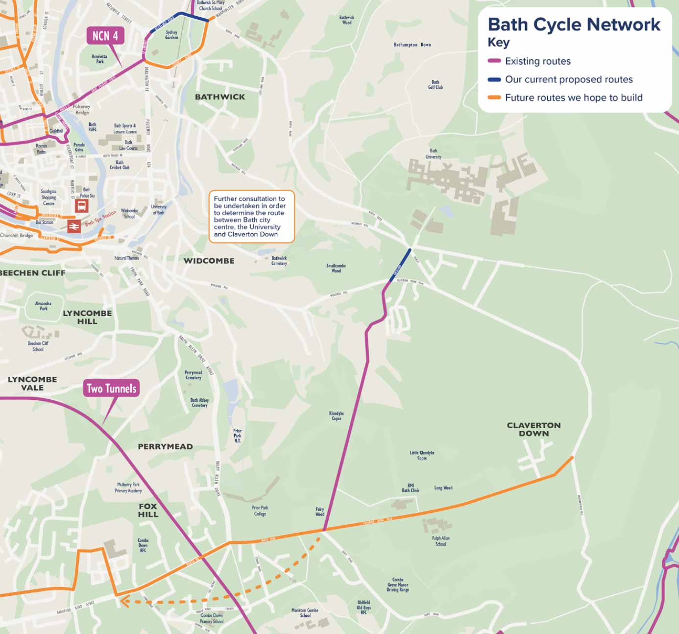
Source: Beckford Road: Traffic Regulation Order (TRO) consultation
Bath River Line
Bath River Line is a project to create a “Linear Park†along the riverside in Bath for walkers and cyclists. The project’s website describes it as follows:
“The Bath River Line (BRL) will create a linear park following the River Avon from Batheaston to Newbridge. Covering 10km, the BRL will connect beautiful green spaces and city landmarks, tempting pubs and peaceful water meadows.
Creating a high-quality route for walking and cycling is key. But the BRL will also offer opportunities to stop, sit back and enjoy the beauty of the river, the city, and the landscape beyond.â€
Creating a high-quality route for walking and cycling is key. But the BRL will also offer opportunities to stop, sit back and enjoy the beauty of the river, the city, and the landscape beyond.â€
In the Bath River Line “Emerging Vision†document, the proposal currently includes two methods of connecting Great Pulteney Street to the canal – a “slow way†through Sydney Gardens, with a complementary cycle path suggested on Beckford road.
However, in its first phase, the project will focus on the Western section of the River Line (between Newbridge and Green Park).
New Sydney Place LTN
The proposed Low Traffic Neighbourhood (LTN) at New Sydney Place aims to improve infrastructure for pedestrians and cyclists on Sydney Road and along New Sydney Place.
One of the main objectives of the LTN scheme is to “enable more local trips by active modes of travel and public transport, through providing easy, safe and comfortable routes within neighbourhoods in line with the wider public health outcomesâ€.
The LTN proposal would have the following benefits for cyclists:
- Removing traffic and the negative impacts of overweight, speeding and polluting vehicles.
- Improving walking and cycling spaces, including access to the Holburne Museum, Sydney Gardens and the Kennet & Avon Canal.
- Planning for upgraded cycle storage facilities.
Links
Better By Bike Regional Cycle Maps
Bath River Line
B&NES Active Travel Schemes